Wikipedia

Search results

Wednesday, August 12, 2020

Militaries around the world are already rocketing beyond the scope of space law

 A pair of recent reports point to growing space conflicts, but the efforts to prevent them are stagnant or out of step.

Three rocket parts housed at the Kennedy Space Center in Florida.SpaceX

Ramin Skibba is an astrophysicist turned science writer and freelance journalist who is based in San Diego. This story originally featured on Undark.

On April 22, Iran’s Islamic Revolutionary Guard Corps announced a successful launch of what they described as a military reconnaissance satellite, which came after several failed attempts. The satellite joined a growing list of weapons and military systems in orbit, including Russia’s test of a missile system designed to destroy satellites, also in April, and India’s test of an anti-satellite weapon, which the country launched in March 2019.

Experts like Brian Weeden, director of program planning at the Secure World Foundation (SWF), a nonpartisan think tank based in Broomfield, Colorado, worry that these developments—all confirmed by the newly reestablished United States Space Command—threaten to lift earthly conflicts to new heights and put all space activities, peaceful and military alike, at risk. Researchers at SWF and the Center for Strategic and International Studies (CSIS), a nonpartisan think tank in Washington, D.C., both released reports this year on this rapidly evolving state of affairs. The reports suggest that the biggest players in space have advanced their space military abilities, including anti-satellite weapons, which destroy satellites, and technologies that merely disrupt spacecraft, for instance by blocking data collection or transmission.

Many of these technologies, if deployed, could ratchet up an arms race and even spark a war in space, the SWF and CSIS researchers caution. Just blowing up a single satellite scatters debris throughout the atmosphere, said Weeden, co-editor of the SWF report. Such an explosion could hurl projectiles in the paths of other spacecraft and threaten the accessibility of space for everyone.

“Those are absolutely the two best reports to be looking at to get a sense of what’s going on in the space community,” said David Burbach, a national security affairs expert at the U.S. Naval War College in Newport, Rhode Island, who was not involved in the new research.

The world is very different today compared to the Cold War era, Burbach added, when access to space was essentially limited to the US and the Soviet Union. Now, the countries involved in space have expanded beyond the US and Russia—especially India, Iran, and North Korea, but also France, Japan, and Israel.

Despite this expansion, as well as the array of new space weapons, relevant policies and regulatory bodies have remained stagnant. “What worries us in the international community is that there aren’t necessarily any guard rails for how people are going to start interfering with others’ space systems,” says Daniel Porras, a Space Security Fellow at the United Nations Institute for Disarmament Research in Geneva. “There are no rules of engagement.”

The new reports use available evidence and intelligence to explore a range of weapons that American, Russian, and Chinese militaries are developing or testing—or already have operational. Notably, CSIS’s report doesn’t include the U.S. But many of the think tank’s top corporate donors are U.S. weapons manufacturers, including Boeing and Lockheed Martin. CSIS is closer in outlook to the Pentagon and to industry than SWF, Burbach said, but they don’t cater to specific donors. In contrast, SWF’s stated purpose is “dedicated to the secure and sustainable use of space for the benefit of Earth and all its peoples.”

The researchers also assessed the advancing programs and weaponry of newcomers. Each nation has unique abilities and characteristics. For example, India has invested heavily in space infrastructure and capabilities, while Japan’s post-World War II space activities were limited until a recent change to its constitution. For Israel’s space program, Weeden said, there isn’t a lot of good data available.

Potential missile attacks on military satellites “tend to get most of the attention, but that is not all that we see happening around the world,” says Todd Harrison, director of the Aerospace Security Project at CSIS and a principal author of their report, during a live stream on April 6.

For example, there is the potential collateral damage to the thousands of everyday satellites that already circle low-Earth orbit, below an altitude of 1,200 miles. About half are from the US—many of the rest are from China and Russia—and provide key services like internet access, GPS signals, long-distance communications, and weather information. Any missile that smashes into a satellite—either as an attack or during a test—would disperse thousands of bits of debris, any one of which, still hurtling at orbital speeds, could take out another spacecraft and create more debris.

“It’s very easy to pollute space,” Burbach says. “The debris doesn’t discriminate. If you create debris, it might just as well come back and hit one of your own satellites. So I think we’re pretty unlikely to see countries actually use those capabilities.” Still, he says, “it would be worrying to see countries showing off that we can do it and start testing.”

When China conducted an anti-satellite missile test in 2007, it created a massive cloud of space junk that drew international condemnation. India’s engineers tried to limit debris by conducting their recent test at a low altitude, so that Earth’s gravity would pull pieces down, where they would burn up on descent. But some pieces flung up to the International Space Station’s orbit. There were no collisions, and as of February, only 15 trackable pieces of debris remained in orbit, said Victoria Samson, director for the Secure World Foundation’s Washington office, during the April 6 CSIS live stream.

As for new military technologies, the experts say many would be worrying to adversaries. France, for instance, is working on laser beams fired from the ground that could dazzle a spy satellite, preventing it from taking pictures of classified targets; North Korea on jamming radio frequency signals sent to or from a satellite; and Iran on cyberattacks that could interfere with a satellite’s systems. Meanwhile, the big three space heavyweights, the U.S., Russia, and China, are already capable of all three approaches, according to SWF report.

The big three also have begun to master what the reports call “rendezvous and proximity operations,” which involve using satellites as surveillance devices or weapons. One country’s satellite could maneuver within miles of a rival’s classified satellite, snap photos of equipment, and transmit the pictures down to Earth. Or if one satellite sidles up to another, it could spray its counterpart’s lenses or cover its solar panels, cutting off power and rendering it useless. Russia may be ahead with this technology, having already launched a series of small “inspector satellites,” as they’re called by the Russian Ministry of Defense, and last fall, according to Gen. John “Jay” Raymond, Chief of Space Operations for the US Space Force, one crept near a US spy satellite, which he referred to as “potentially threatening behavior.”

So far, there are no international policies or norms to tell militaries what’s allowed in modern-day space and what’s not. An incident or a misunderstanding could escalate tensions if it’s perceived as an armed attack, the SWF report argues.

The lack of guidance has left room for a range of activities. In December 2019, the Trump administration signaled its intention to strengthen US space weapons and protect US spacecraft from possible attacks by Russia and China, Weeden said, by transforming the Air Force Space Command into Space Force. The shift “brought a full-time operational focus to the space domain, which was a needed change,” writes US Space Command Spokesperson Lt. Col. Christina Hoggatt in a statement to Undark. With these forces, the Defense Department seeks to “strengthen deterrence” and improve capabilities to “defend our vital assets in space,” she writes. This emphasis likely means that US military will focus on making satellites more resilient to attack, Burbach says, rather than developing offensive weapons.

Unlike the US, smaller space powers have few satellites and therefore less to lose, Porras says. He argues that a tense regional relationship could be particularly unpredictable. For example, he says, North Korean leaders, in a standoff with South Korea and the US, might decide to launch and detonate a nuclear weapon in space, which would burst and propel dangerous radiation that would disable most satellites.

The U.N. and other international groups, including SWF and the Outer Space Institute, a global research organization based in British Columbia, are working to avoid such scenarios. As long as countries don’t launch a destructive space weapon near others’ spacecraft, conduct an overtly provocative test, or disable a critical satellite, peaceful space activities could continue, Weeden says. For now, he points out, countries have only tested missiles on their own defunct satellites, while exercises against other countries’ spacecraft have remained non-destructive.

The only existing international laws offer little guidance for modern weapons in space. While they prohibit weapons of mass destruction in space, they don’t explicitly limit the use of other kinds of space weapons, weapons tests, or military space forces. These laws include the Partial Nuclear Test Ban Treaty, which passed in 1963, and the U.N.‘s Outer Space Treaty, which was passed in 1967.

Weeden points out that space diplomats could create new guidelines by developing something like the Incidents at Sea agreement, which the US and the Soviet Union agreed upon during the Cold War to maintain a safe distance between ships and avoid maneuvers in heavy traffic. But until such rules are hammered out, he said, any unexpected satellite tests will inevitably fuel speculation and paranoia.

“Any time you have militaries operating near each other without a lot of transparency or clarity,” he adds, “you always have the opportunity for misperceptions that could lead to something very bad.”


Flying over mountains isn’t as scary (or hard) as you might think

 A pilot details her return to the high-country skies.

“I shopped the Strip at Mahoney Creek only to see its windsocks voting in opposite directions.”Julie Boatman


This story originally featured in the May 2020 issue of Flying Magazine.

My relationship with the mountains began on hikes with my family, camping trips up into the farthest corners of Glacier National Park that could be reached with a 7-year-old (me) and a toddling 4-year-old (my little brother) in close formation. We took what we could carry in our little packs—supplemented heavily with the resources my parents stuffed into their own.

Fast-forward to my early flight-instructing years in Colorado, where one of my greatest joys was introducing pilots to the high country—famously high-altitude airports like Leadville, Telluride and Aspen. The “real” backcountry beckoned, though, and about 15 years ago, I took a condensed, one-on-one mountain flying course with well-known backcountry instructor Lori MacNichol, through McCall Mountain Canyon Flying Seminars. The flights I made there cemented my love for the high country and, more so than that, provided me with a skill set that could be applied to much of my everyday flying.

Indeed, these lessons that the mountains bring to us know no gender, age or aviation background. So, when Christina Tindle from WomanWise Aviation Adventures dropped me a note on Twitter, asking my interest in joining them for an upcoming seminar in Cascade, Idaho, I was intrigued by two things: how flying with like-minded pilots would enhance my experience (or detract from it) and how much I would recall from my previous time flying into the Idaho wilderness.

A psychologist and counselor by occupation—and backcountry pilot—Tindle launched a series of seminars in 2011 with a fly-in to Smiley Creek, Idaho. In 2019, she conducted four events in Idaho and Colorado, focusing on backcountry flying but also touching on other areas of flight based on the requests of participants, including upset and recovery training, aerobatics, floatplane flying, and primary tailwheel instruction.

“These ­lessons the mountains bring to us know no ­gender, age or aviation background. ”Julie Boatman
I knew this aviation seminar would be different when Tindle sent me a pre-event registration packet that included an overview with the quote, “If the shoe fits, you’ll dance a lot longer.” While the questionnaire accompanying the notes asked me to list standard items such as my flight time and recency of experience—and relative comfort flying in the backcountry—it also asked an open-ended question, “What do you want from your experience at WWAA?”

You could respond with a simple answer, or you could dive in more philosophically. Given that the registration form also noted that we would be formulating Life Flight plans, the intention with the question was clearly broader than simply probing our need to improve our confined-airstrip-landing skills.

Because I would be a speaker at the seminar, giving a presentation on coping with life’s “go-arounds” (often mistakenly referred to as “failures”), I left my answer generic, knowing I’d address the very topic I wanted to work on—extrapolating the confidence I’ve often gained from flying into my life on the ground—in my talk with the group.


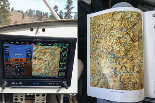
A careful study of the terrain and airport ­information ­before you fly is critical—but takes on even more significance in the mountains.

Preparation and planning

Weather in Cascade in the third week of September can offer up anything from summer-like temps and density-altitude concerns to drizzly clouds and mountain-obscuring ceilings—or even a blizzard. I scheduled two days of instruction according to the forecast, knowing I could add an aerobatic flight or some tailwheel practice as the actual conditions allowed.

To balance the flying time, Tindle scheduled briefings from the instructor corps in the afternoons and evenings. For example, in one evening, Bob Del Valle of Hallo Flight Training (based in Priest River, Idaho) covered key concepts, such as engine failure after takeoff and accelerated stalls, as well as decision-making skills tuned to the environment in which we’d fly.

I spent my first day of flying with Fred Williams, an instructor who splits his time between Cascade and Reno, Nevada. He offered up his Kitfox with large-format tires for our flying—an airplane I’d flown only briefly with a friend in the more urbane environs of airpark-rich Florida.

The practice area

Once briefed, we launched into blue and headed east to the practice area, in the valley hosting the Landmark, Idaho, airstrip (0U0). Before reaching the airport vicinity, Williams had me practice canyon turns in the broad valley, slowing down bit by bit to tighten them up. A canyon turn takes advantage of the fact that reducing your airspeed decreases the radius of your turn. If you execute a turn using a 30-degree bank at a near-cruise, density-altitude-adjusted groundspeed of 120 knots, the radius of your turn is 2,215 feet. At a speed near VA for many single-engine airplanes—say, 90 knots—you take up a lot less real estate, at 1,246 feet. If you can safely reduce your speed to 60 knots, that figure drops to 553 feet, and you can just about execute a 180-degree turn in 1,100 feet laterally. Use of flaps can help maintain a slower speed—making a huge difference when you contemplate a course reversal below canyon walls.

But those take practice to execute well. In Del Valle’s briefing, he had gone over the increased stall speed inherent with a turn of increased bank. With a bank angle of zero, let’s say your airplane has a stall speed (VS) of 60 knots. At 30 degrees of bank, that speed increases 10 percent to 66 knots; at 45 degrees of bank, it’s up to 72 knots. Because the Kitfox’s VS was much lower than 60 knots—try 49 mph with no flaps—we had a lot of room to play with, but still the smaller the bank, the less the chance we’d run into accelerated-stall territory. A good canyon turn is a balance of these aspects.

Surveying the strip—what some pilots call “shopping,” a term I first heard from MacNichol 15 years ago and in common usage among Idaho pilots—takes practice, too. Flying an extra traffic pattern gives you time to ferret out the details. Sometimes, you have to do this a lot higher than a standard traffic-pattern altitude, and you might not have sight of the strip during the approach until you’re on short final.

At Landmark, we had a relatively wide-open valley in which to maneuver as we gauged the status of its 4,000-foot-long, 100-foot-wide surface. As we worked through the day, flying to Indian Creek (S81) and Thomas Creek (2U8), we would need progressively more-inventive ways to survey the landing site before making our approach. On day two in the 182, we would do the same with instructor Stacey Burdell, scoping the scene at Stanley (2U7), Smiley Creek (U87), Idaho City (U98) and Garden Valley (U88), consecutively.

Checking the actual weather against the forecast also proved most important, especially because of the winds at ridge-top level contradicting those at the surface—or even at the ends of the same runway. With Williams on day one, I shopped the strip at Mahoney Creek (0U3) only to see its windsocks voting in opposite directions. As much as I wanted to land there and tag another new strip in my logbook, we left it for another day. We bounced around enough on the way back to Cascade (U70) to validate my choice.

A stabilized approach

If you have this image of a backcountry pilot making crazy maneuvers to “make it” to a landing, dispel them from your mind right now. If you have any sense, you won’t accept anything less than a stabilized approach—and you’ll bail out early if you can’t maintain your airspeed and sight picture.

That said, the stabilized approach to a backcountry strip looks a little different than the one you might use in normal ops. This stems directly from the fact many mountain strips are one-way-in runways and have a “point of no return,” after which you must make the landing. A super-low-speed, power-off, short-field approach doesn’t offer the same margins for adjustment at the last minute that the backcountry approach does.

We practiced at Landmark—which has no point of no return because of its position in the valley—setting up a steep, low-power descent at a moderate rate, with full flaps in the Kitfox (think 30 degrees if you were flying a Cessna 172) and a speed at 1.2 to 1.3 times VSO, which correlates to about 55 mph indicated in the Kitfox. This configuration offers the ability to use more or less power if needed and modify the descent rate to avoid landing short—or long.

The key is to lock this in well before you reach your predetermined go-around point. If you don’t have the configuration in place and stable, you need to execute the go-around before that point of no return, or you risk everything. One of the approaches on day two was not well-stabilized, at Garden City, and it drove home the necessity of staying diligent about this practice—and being locked and loaded to go around if you’re too high and too fast at the key position, rather than forcing the approach.

Life lessons

There’s an aspect of facing and conquering the unknown that carries over into the rest of your experience. The mountains are personal to me, and returning to them at a perfect time in my life, when I needed a shot of self-confidence, made all the difference in the world.

As weather drew in on day three, we bagged the airport activities for a hike into a nearby hot springs as the snow fell around us. The camaraderie was real as we navigated slippery rocks, and it would continue on in the aviation friendships I made that week. Our Plan B was just fine—and executing it reiterated the joy of taking advantage of life’s sharp turns. A disappointment became an opportunity to enjoy the natural beauty of a place we could access through general aviation. That’s another lesson that feels particularly poignant now as we face uncertainties ahead in life.

On the last evening of the seminar, the group encapsulated our plans for the coming days, weeks and months into concrete goals. Mine was simple: to keep flying. To keep exploring new places only an airplane can reach. To tap into that well of confidence-building stuff that only learning to fly has provided me. And that too is something every pilot can take away.

Mountain skills you can use every day

  1. Pay attention to micrometeorology—and understand how fast the weather can change. In both the mountains and the lowlands, the environment immediately surrounding an airport can funnel winds and generate up- and downdrafts worthy of note, along with localized clouds and reduced visibility.
  2. A stabilized approach is a safe approach. While you might use a different technique for your approach to a “normal” runway, setting a configuration and rate of descent to have in place by the time you’re at 500 feet agl—or higher—will stack the deck in your favor for a better landing.
  3. Practice and plan for a go-around every time. In the backcountry, your go-around decision point might not be over the runway, or even on short final. Committing to a go-around plan, and knowing when you’ll trigger it, is vital. This holds true with every single landing you attempt.
  4. The go/no-go decision continues throughout the flight. While you may consider the flight launched once you’re airborne, you’re always in a position to return to the place you just left, divert, or come up with some alternative to the plan you had in mind. This mental flexibility may very well save your life someday.
  5. Take the right equipment. Save room (and weight) for a well-stocked flight bag—one that holds an extra layer of clothing, a hat, a first-aid kit, food and water, and other emergency supplies. Landing out, even in the flatlands, can leave you far from assistance.

Required reading

Two books guided my research, and a host of content online supports the topics they cover.

If there’s a primary textbook for flying in the high country, Mountain, Canyon, and Backcountry Flying by Amy L. Hoover and R.K. “Dick” Williams is it. Hoover has been flying the Idaho backcountry since 1989 and started teaching mountain flying in 1992 while working as a backcountry air-taxi pilot. She’s an original co-founder of McCall Mountain Canyon Flying Seminars. For the book she teamed up with pilot legend and author Dick Williams, who started training pilots in the backcountry in 1985. It’s available through Aviation Supplies and Academics.

For those who want their mountain flying in concise form, seek out a copy of Mountain Flying by Sparky Imeson, published in 1987 by Airguide Publications. Imeson, who ironically died in a March 2009 accident involving his Cessna 180 in the mountains, founded Imeson Aviation in 1968 at the Jackson Hole Airport in Wyoming. His wisdom—and the website, mountainflying.com—lives on, disseminating his vast knowledge of the techniques and decision-making critical to flying safely in the backcountry.

More aviation adventures

Tindle plans more WomanWise Aviation Adventures for 2020, though at press time they remain in flux because of general travel concerns in the spring, which we all hope to have dissipate by summer. Tindle said in March, “[I’m planning] September 6 to 10 in Steamboat Springs, Colorado, for high-mountain flying, aerobatics and spin [training], and soaring, which is new. [Then it’s] October 25 to 29 in Moab, Utah, for backcountry flying, aerobatics and spin [training], and ballooning—also new.”

Check womanwiseaviationadventures.com for more details.

Also, look to Fred Williams’ Adventure Flying LLC for the wide range of flight training he provides in Cascade, Idaho, and Reno, Nevada, both in the Kitfox or in the aircraft you bring (contact Williams for details via advflying.com). Bob Del Valle offers instruction in Sandpoint, Idaho, as well as around Montana and Washington (halloflighttraining.com). Sam Davis offers instruction in aerobatics, as well as upset prevention and recovery, in the Heber City, Utah, area through Pilot Makers Advanced Flight Academy (pilotmakers.com).

Police can surveil protests from participants’ pockets and homes


Protesters in Portland now have to contend with local law enforcement and federal officers. Technology may either help or hurt them.Tito Texidor III

Anjuli R. K. Shere is a doctoral researcher in Cyber Security at the University of Oxford. Jason Nurse is an assistant professor in Cyber Security at the University of Kent. This story originally featured on The Conversation.

US police forces have been turning to technology to track down Black Lives Matter protesters. Content from social media platforms and affiliated sites has been instrumental in the authorities being able to identify protesters based on photos of their faces, clothes and hair, or on the fact that they posted while at the protests. Meanwhile, drones have been added to the police’s own means of capturing footage of the protests.

Making technology-driven state surveillance part of the police’s response to democratic protest sets a dangerous precedent. There is a risk that the power this gives to police to target protesters could be abused and have a chilling effect on freedom of speech and assembly. This is particularly true in the case of Black Lives Matter, given alleged evidence of the infiltration of US law enforcement agencies by white supremacists.

What’s more, the amount of data on people that is gathered by technology and potentially available to law enforcement is set to grow thanks to the rapid expansion of internet-connected devices (known as the Internet of Things, or IoT).

The Internet of Things could, if left unchecked, give authorities seemingly unlimited ways to mine for information on people, both users of the technology and bystanders. Voice-operated assistants such as Amazon Alexa and Google Home record our conversations; smart watches and fitness trackers monitor our movements, and even many traditional home appliances now collect data on us, from smart fridges to washing machines.

The growing prevalence and variety of these devices means a huge amount of data can be compiled on us by corporations in the name of improving user services or targeted advertising. But thanks to recent surveillance laws, state authorities can also request and gather a large amount of this data. And government bodies are already starting to capitalize on the new capabilities provided by the Internet of Things.

For example, some IoT technologies, such as internet-connected Amazon Ring doorbells that can record video footage, have become an informal addition to state surveillance infrastructure. Ring’s partnerships with police forces gives them access to camera locations so they can request footage from specific device owners (and obtain it by warrant if they refuse).

Some deals have involved giving away the doorbells to the public for free. This effectively creates a cheap state monitoring network that has reportedly led to racial profiling among users.

Threat to protesters

IoT technology also could be used specifically against protesters, activists, and journalists. Not only could collected data be used to identify or track people even more effectively than social media posts, but reliance on the technology could also leave people and groups vulnerable to cyber attacks.

For example, in Hong Kong we’ve seen attempts to disrupt the communication of protesters and force them to use less secure channels that can more easily be monitored. There’s even a chance that the rise of hackable internet-connected cars could lead to more vehicular attacks on protests, as have occurred against anti-racism demonstrations in the US.

Despite these threats, our recent research shows journalists in particular are not generally aware of or protected from IoT technology being used to target them. What’s more, having your data gathered by IoT devices might soon be unstoppable even if you don’t own or use them. As part of our research, we surveyed 34 cyber security experts and found that 76.5 percent of them believe that it will not be possible for people to opt-out of interaction with the IoT within the next five years.

You might not be able to walk through a residential street without being filmed, or talk to a family member while in a doctor’s waiting room without your conversation being recorded. For activists and protesters, this huge prevalence of technologies and databases that are accessible to the state means an ever-increasing risk of being identified, tracked and surveilled, as shown by the newly released Atlas of Surveillance.

With the growing threat of state surveillance through the IoT, activists are starting to take measures to protect themselves. More are becoming aware of the risks of taking a registered smartphone, which is essentially a personalized tracking device, on a protest. Others are following the example of protesters in Hong Kong, who recently adopted an informal all-black “uniform” complete with face masks to make it harder for authorities to identify individuals from online photos.

As well as providing secure, independent, encrypted messaging, the app Signal has responded to police forces’ technological identification of protesters by creating a tool that blurs people’s faces in photos. Although programs exists that can attempt to unblur pixelated photos, the fact that so much software isn’t built with Black people in mind could ironically make it worse at revealing the faces of people of color.

This issue reminds us that technology is never neutral, particularly when people exercising their right to protest have their data used against them. In this case, against people fighting against structural racism and police brutality against Black and indigenous people.


Friday, August 7, 2020

Oppo A52 8GB RAM Variant Launched in India as a Part of Amazon Prime Day 2020 Sale


Oppo A52 price in India has been set at Rs. 18,990 for the 8GB RAM variant.Oppo A52 has received a new, 8GB RAM variant in India. The new launch that is a part of Amazon Prime Day 2020 sale comes a few months after the Chinese company brought the Oppo A52 to the country in a 6GB RAM option. Apart from additional RAM capacity, the new variant is identical to its original model. The Oppo A52 comes with a hole-punch display and features quad rear cameras. The smartphone also has 18W fast charging and includes dual stereo speakers, with the Dirac 2.0 audio technology.Oppo A52 price in India, availability detailsOppo A52 price in India has been set at Rs. 18,990 for the 8GB RAM variant. This is Rs. 2,000 higher than the 6GB RAM option that was launched in the country in June with a price tag of Rs. 16,990. Both 6GB and 8GB RAM variants are available for purchase through Amazon. Moreover, the phone comes in Stream White and Twilight Black colour options.Amazon is offering no-cost EMI options and an additional exchange offer on the Oppo A52. Also, HDFC Bank customers can avail a 10 percent instant discount while making the purchase through their debit or credit card or via EMI transactions.Notably, Oppo announced the debut of the 4GB and 8GB RAM variants of the Oppo A52 smartphone during its India launch in June. It, however, didn't provide any exact timelines on their arrival at that time. Also, there are no details on the availability of the 4GB RAM variant of the Oppo A52 that is also due to come with 128GB of onboard storage.The Oppo A52 was originally launched in China in April in the single, 8GB RAM option.Oppo A52 specifications :The dual-SIM (Nano) Oppo A52 runs on Android 10 with ColorOS 7.1 on top and features a 6.5-inch full-HD+ (1,080x2,400 pixels) display with 20:9 aspect ratio and 90.5 percent screen-to-body ratio. Under the hood, the phone has octa-core Qualcomm Snapdragon 665 SoC, coupled with up to 8GB of RAM. It comes with a quad rear camera setup that houses a 12-megapixel primary sensor with an f/1.7 lens and an 8-megapixel secondary sensor with an ultra-wide-angle f/2.2 lens. The camera setup also has two 2-megapixel sensors. For selfies, the phone comes with an 8-megapixel camera sensor at the front. Oppo has provided 128GB of internal storage as standard across both Oppo A52 variants. Connectivity options include 4G VoLTE, Wi-Fi, Bluetooth, GPS/ A-GPS, USB Type-C, and a 3.5mm headphone jack. There is also a side-mounted fingerprint sensor.The Oppo A52 packs a 5,000mAh battery that supports 18W fast charging. Besides, the phone measures 162x75.5x8.9mm and weighs 192 grams.

Google’s Pixel Foldable Phone Tipped to Launch in Q4 2021, Codename Leaked


Google is also said to be working on Pixel 5a and two more devices.

Google's first Pixel foldable device may launch next year, an internal Android document has suggested. This new document indicates that the tech giant is already working on its first foldable device and is looking to launch it in 2021. Alongside the foldable device, the internal document also suggests that Google is also developing Android builds for the Pixel 5a and at least two other devices. The Pixel 5a is presumably the successor to the Pixel 4a launched a few days ago.

9to5Google has accessed this internal Android document that lists builds of all publicly launched Pixels and a few unannounced ones as well. This includes the Pixel 5a that has been codenamed as ‘barbette'. The foldable device is reported to be codenamed ‘passport' and the other two devices that are also under development are reportedly codenamed ‘raven' and ‘oriole'. It can be speculated that raven and oriole are codenames for the Pixel 6 series expected to launch in 2021.

The document explicitly refers to the ‘passport' device as being foldable. The raven, oriole, and passport devices are labelled ‘Q4 2021' hinting at their launch timelines. Google has been rumoured to be working on a foldable Pixel device since last year, and Google executive Mario Queiroz also confirmed the tech giant was indeed experimenting with foldable displays. However, he said that the company was no rush to launch its first foldable phone anytime soon.

A patent filed by Google last year showed Google's foldable smartphone prototype design that featured a display that would fold inwards. The design could be one of the several foldable prototypes Google may have tested. There is no real leak of the Pixel foldable phone up until now, so we can't speculate on the design as of yet.

Google Docs, Sheets, Slides Apps Getting New Features to Improve Content Creation, Collaboration on Mobile


G Suite apps such as Google Docs, Slides, and Sheets get handy updates for both Android and iOS users.

Google has started rolling out several new features for its G Suite apps on mobile platforms. These are designed to help make working on Google Docs, Sheets, and Slides much easier on the go. The freshly added features include Smart Compose, link previews, vertical navigation, dark theme, comments interface, and more. All G Suite customers will be able to access these features on Android or iOS devices, as the updates are gradually rolled out. Google said in a blog post that the new features aim to help mobile users “efficiently create, collaborate, and communicate.”

Google announced the new features in a blog post on Wednesday. The tech giant said that it was announcing enhancements to Google DocsSheets, and Slide mobile apps. You can download the apps to avail these features for Docs (Android/iOS), Sheets (Android/iOS), and Slides (Android/iOS).

Here's a look at the new features introduced in Google Docs, Sheets, and Slides

Smart Compose: This AI-powered tool will help reduce spelling and grammatical errors, and write faster. This feature was made available on the Web earlier this year and is now launching for mobile phones as well. Google said that the Smart Compose will be available on Android and iOS users within a few weeks.

Link previews: Clicking on a link in Google Docs will now show a dynamic card with information about the content, such as thumbnails, owner details, latest activity of Drive file, titles, and more. You can do all of this without having to leave the app, thus not disrupting your reading flow. This feature is available on iOS and will be rolling out to Android within a few weeks.

Comments response: You will now see an up-to-date comment threads around documents in Gmail that you can resolve or reply directly, though the message. This feature was introduced on the Web last year by Google and will now be available for Android and iOS mobile apps as well.

Comments interface: Google has improved the interface for comments, making it easier for team members to collaborate. The new interface makes it easier to scroll through, respond to comments, and @mention others. This is available on Android and will be rolled out to iOS within a few months.

Vertical navigation: You can now look at slideshows in a vertical stream in slides, using pinch-to-zoom feature. This will help make reviewing presentations faster and make it easier to switch to editing or presenting content. This will be available on Android within the next few weeks, and on iOS in the next few months.

Dark theme: Dark theme is supported in Docs, Sheets, and Slides on Android, and will be available on iOS in the coming months, according to Google. This feature rolled out in July.

Wednesday, July 29, 2020

Occupants Check Into NASA’s “Robot Hotel” Aboard the Space Station

Mobile Base System Mobile Transporter
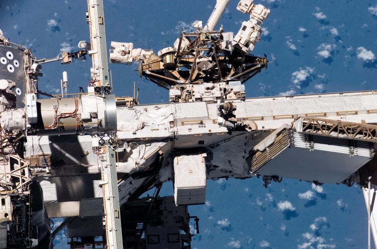
The Mobile Base System moves on the Mobile Transporter rail car along truss rails covering the length of the space station. It provides a movable platform for Canadarm2 and Dextre and can access any of eight worksites that feature power connections. Credit: NASA
Storage is just as important aboard the International Space Station as it is on Earth. While the space station is about the size of a football field, the living space inside is much smaller than that. Just as you wouldn’t store garden tools in a house when you could store them in a shed outside, astronauts now have a “housing unit” in which they can store tools for use on the exterior of the space station.

On December 5, 2019, a protective storage unit for robotic tools called Robotic Tool Stowage (RiTS) was among the items launched to station as part of SpaceX’s 19th commercial resupply services mission for NASA. As part of a spacewalk on July 21, NASA astronauts Robert Behnken and Chris Cassidy installed the “robot hotel” where the tools are stored to the station’s Mobile Base System (MBS), where it will remain a permanent fixture. The MBS is a moveable platform that provides power to the external robots. This special location allows RiTS to traverse around the station alongside a robot that will use the tools it stores.
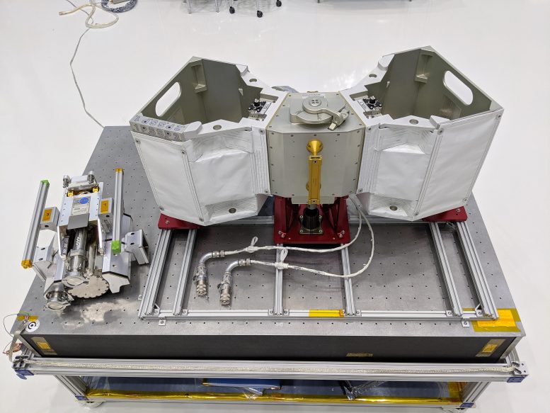
RELL Engineering Development Unit and RiTS Flight UnitRELL Engineering Development Unit (left) pictured alongside RiTS. Credit: NASA


“RiTS provides thermal and physical protection for tools stored on the outside of station, not only freeing up room on board but also allowing the Canadian Space Agency’s Dextre robot to access them more quickly,” said RiTS Hardware Manager Mark Neuman.

The first step in the RiTS installation process involved preparing the unit inside the space station. The astronauts unpacked RiTS’ occupants from storage – two units of a tool called the Robotic External Leak Locator (RELL) – and affixed them inside RiTS’ aluminum housing.

Astronauts RiTS Installation

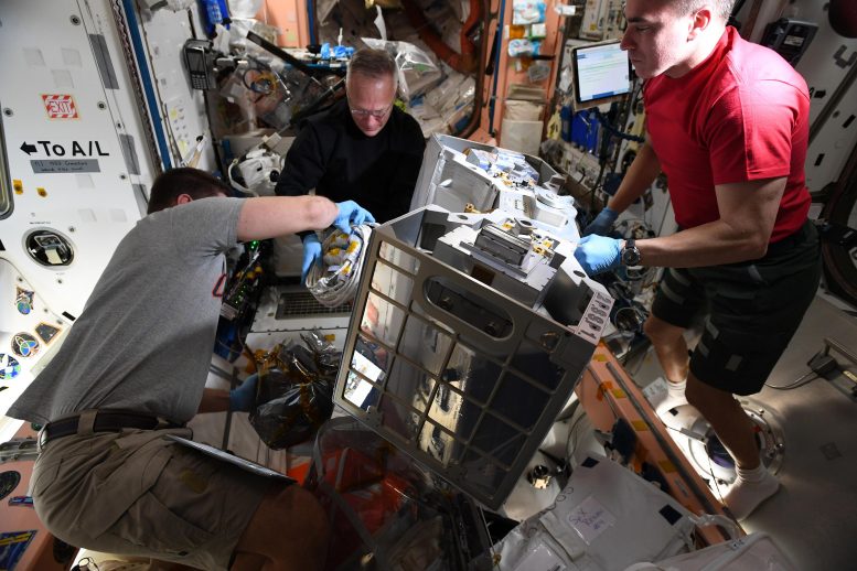
Astronauts Robert Behnken, Doug Hurley, and Chris Cassidy prepare RiTS for installation. Credit: NASA

“RELL is a great example how robots with the right tools can simplify life for astronauts,” said Neuman. “Dextre can use RELL to detect ammonia leaks, eliminating the need for astronauts to perform the same task during a spacewalk.”

The ability to locate and repair ammonia leaks efficiently is important since ammonia is used to operate station’s cooling system.

Mobile Base System Mobile Transporter

The Mobile Base System moves on the Mobile Transporter rail car along truss rails covering the length of the space station. It provides a movable platform for Canadarm2 and Dextre and can access any of eight worksites that feature power connections. Credit: NASA

The installation of RiTS makes the leak location process much more streamlined. Before RiTS, the RELL tools were stored inside the station, and deploying RELL depended on airlock availability and involved waiting an additional 12 hours to allow for RELL’s gas analyzer to clear itself of internal gases. With RiTS, the only variable is Dextre’s availability, expediting the search for leaks.

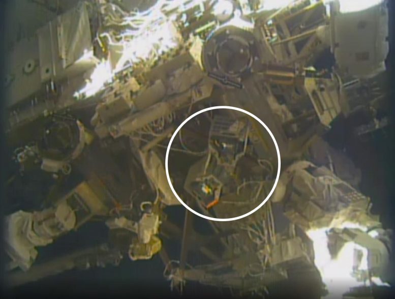
After it was prepared on station, RiTS – loaded with the two RELL units – was sent outside with the spacewalking astronauts who attached it to the MBS. This was the first task during a spacewalk to upgrade International Space Station systems. The installation required the astronauts to mechanically attach RiTS to an available worksite socket then mate two electrical cables to unused power outlets on the MBS. The power connection was critical to enabling heaters within RiTS that keep the RELL tools from getting too cold.

RiTS Installed on ISS

RiTS installed on the space station. Credit: NASA TV

Although RiTS will be used on the station, human-robot collaborations like this have the potential to be applied to other endeavors that involve human habitats in space, including Gateway.

RiTS was developed by NASA’s Exploration & In-space Services projects division at the agency’s Goddard Space Flight Center in Greenbelt, Maryland, in partnership with NASA’s Johnson Space Center in Houston.